
Joshua Dill: Please tell us about your background and your work at EBID.
Erek Fuchs: I am currently the groundwater resources director at EBID. I hold a PhD in quantitative hydrology with a focus on groundwater resources, and I’m particularly interested in conjunctive- use environments where irrigated agriculture is prevalent. I’ve been with EBID for almost 8 years. Prior to that, from 1999 to 2011, I was with the New Mexico Office of the State Engineer, based right here in Las Cruces, as the Lower Rio Grande basin supervisor.
I’m a native New Mexican. I grew up on a little ranch in south-central New Mexico near the small town of Capitan and went to college at New Mexico State University (NMSU) in Las Cruces. All my degrees are from NMSU. I also attended Kansas State University for about a year and a half right after I completed my MS degree in 1997, working on watershed, range hydrology, and water quality issues. Otherwise, I’ve been in Las Cruces for quite a few years.
I’m delighted to be with EBID. My work here is far more applied and satisfying than the regulation work I was doing in years past. This position has afforded me the opportunity to directly engage with farmers and producers and to learn from them, which I really enjoy, to carry out applied science, and to develop research ideas. I also have a hand in developing water policy in this part of the world. EBID is a conjunctive-use system, which is to say that surface water and groundwater, particularly the shallow alluvium groundwater, are highly interrelated. Ultimately, groundwater at depths well below the shallow alluvium is interrelated also. It is critical to understand those connection dynamics.
In our system on the Lower Rio Grande, groundwater has been administered by the Office of the State Engineer since 1980. The administrative functions that the Bureau of Reclamation carried out with regard to surface water within EBID and the Rio Grande Project were largely taken over by EBID back in 1979, when our farmers finished repaying the federal government for the Rio Grande Project, while the State Engineer has remained focused on groundwater as a matter of law. These separate administrative functions in an otherwise interrelated system can get complicated.
EBID had the foresight to install its own groundwater-monitoring program years ago. It came online in mid-2009. Before that, EBID was largely dependent on Reclamation, the U.S. Geological Survey, and other governmental entities for data and information concerning our groundwater resources.
Presently, we have 52 monitoring wells in the Mesilla Valley, which is the larger, deeper and more extensively used aquifer in our system. The Mesilla Valley is consistently recognized as one of the top producers of high-quality pecan nuts in the country. Further north in the Rincon Valley, which is a much shallower and narrower aquifer system, EBID has 13 wells. The 65 monitoring wells are instrumented to serve as piezometers. They’re all on remote telemetry units and provide us with real-time data. That’s important because, as my board of directors has said, if we can’t measure it, we can’t manage it. Numeric modeling is only as good as the data we use to calibrate and run models.
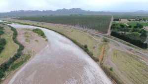
Another important aspect of our system and farming practices is that there’s basically a one-to- one relationship between surface water availability and groundwater pumping during the irrigation season. Drought conditions result in increased dependence on groundwater for irrigation. EBID’s system includes Elephant Butte Reservoir, which is our primary storage for surface water, and Caballo Reservoir just downstream, which is mostly a regulating feature for surface water releases during the irrigation season. Although we get some local precipitation with our summer monsoonal rainstorms, it is a pretty inconsequential part of the overall irrigation water budget. We’re far more concerned about snowpack in southern Colorado and northern New Mexico because the spring snowmelt and runoff feeds the Rio Grande and its tributaries and is delivered, under the terms of the Rio Grande Compact, into Elephant Butte Reservoir. That is basically the usable surface water we have to irrigate with from year to year, but we also have an aggressive stormwater capture program to make efficient use of every drop of surface water we can pick up locally.
In recent years, we’ve suffered significant surface water shortfalls due to regional drought, and in turn, there’s been more groundwater pumping to make up the difference to meet crop requirements. This has led me to develop a metric of groundwater resilience, which I would describe as the capacity of our aquifer system to absorb stress. My concept, which
I have written about in the Journal of Hydrology, is the groundwater/ surface water ratio of application (GSRA). The GSRA is simply the total volume of groundwater extracted and applied through irrigation per unit of time, divided by the total volume of surface water diverted and applied for irrigation per unit of time within a common river basin and interrelated aquifer system such as ours. Over time, especially when combined with other empirical hydrologic considerations specific to the system under study, the GSRA can inform work on aquifer recharge, safe yield, and water resource sustainability. It is a useful metric because it necessarily captures several important measures of the interrelationship between surface water and groundwater.
That brings up another focus of my work, which is connectivity physics and the different flow regimes between the surface water in the river and the underlying aquifer. An ideal circumstance is a connected and gaining system, but what is more common is a connected but losing system. When the river is losing water, it is effectively recharging the aquifer, which is by no means a bad thing. There is a balance between river efficiency and seepage, or infiltration flux from the riverbed into the aquifer. There is also a transitional flow regime, in which the water table below the riverbed is receding or starting to disconnect from the riverbed itself. Disconnection is a circumstance in which, in an otherwise hydraulically interrelated river and aquifer system, there is an unsaturated zone between the top of the capillary zone overlying the groundwater table and the base of the riverbed. That most often reflects an abnormally perched river and is an indicator of groundwater stress. That’s something that we’re working to better understand, especially because once disconnection occurs, the infiltration flux or infiltration rate through the river and riverbed to the aquifer is at a maximum, at least relative to the river stage. In other words, it is a situation of maximum seepage or loss of surface water that we would otherwise deliver to our farmers for irrigation. That water can be, and oftentimes is, recovered through groundwater pumping, but groundwater pumping further stresses the aquifer system, to say nothing of the fact that it’s expensive.
Riverbed sediment accumulation further impedes river efficiency. It likely increases the frequency and duration of disconnection, especially during drought conditions, which further reduces river efficiency and impedes our ability to deliver surface water to farmers to irrigate. This leads them to pump more groundwater, which creates a positive feedback loop with costly effects. Riverbed sediment accumulation can also reduce a system’s capacity to handle flooding.
The excavation of excess riverbed sediment becomes particularly expensive and difficult when it accumulates over time. The trick is to maintain a regular maintenance program, excavating and removing excess sediment periodically before it turns into a major problem. Something similar can be said for upland watershed management. The heavy equipment and time needed to excavate sediment can be expensive, so how are we supposed to pay for it? I think there is a good argument for it to be covered in part by Reclamation infrastructure improvement–type activities. Effective river channel maintenance would increase river efficiencies while also improving our capacity to handle flood flows when they occur. An understanding of connectivity and related physics might also allow us to take advantage of flood flows to facilitate aquifer recharge.
Joshua Dill: What about your research is least understood by the industry at large?
Erek Fuchs: Probably the biggest challenge is connecting with the urban, nonproducing members of our community and helping them understand the importance of irrigated agriculture in our area. People are quick to criticize irrigated agriculture in the desert Southwest as nonsensical, but we are not irrigating the desert. We are irrigating fertile farmland in the riparian corridor of the lower Rio Grande and growing crops that the world demands, which a great many scientists, engineers, and Reclamation folks long ago figured out was a good idea. That’s why the Rio Grande Project was conceived.
When it comes to my research, connecting with the producers on the ground remains a bit of a challenge, even though they clearly have a huge stake in the topic. Some are interested in it from a technical point of view; they ask questions, do follow up, and do some of their own reading. Others are just too busy trying to grow their crops and make a living, which is getting harder and more expensive with the more frequent droughts. We’re trying to develop educational materials and are wondering if there’s an opportunity to partner with Reclamation or the NMSU cooperative extension service to come up with better materials. When it comes to my published journal articles, it is mostly only other scientists that get much out of that. We need to be able to effectively communicate our research to the folks who would most benefit from it. That has major implications, because the greatest opportunities for better water management are at the local, rather than the regional, level.
Joshua Dill: Would you give some concrete examples of how your research has potential for improving water management at irrigation districts?
Erek Fuchs: The problem right now is that there’s so much litigation in play on an interstate level, which creates tremendous uncertainty and makes implementing our ideas difficult. I think we’re going to have to get to a point where some of the interstate disputes are closer to settled. I’ve got data and I’m reaching hydrologic conclusions, but in terms of actual implementation, most of what we have seen so far has been individual farming operations adapting to drought conditions on the fly.
That said, we are also see something of the opposite. Just the other day, newspapers around here were touting the fact that New Mexico is the number 1 pecan producer in the country, which can be attributed primarily to a
number of the larger Mesilla Valley pecan operations within EBID. Here at EBID, we continue to see more land going into orchards, which reduces the flexibility of adaptive management because pecan orchards are something you can’t fallow. If pecans are essentially the only crop that makes sense from a market perspective, it is no wonder that more growers are trending that direction. However, we need to find creative, hydrologically sound ways to balance water demands so that the resilience of our aquifer system isn’t compromised in the long run.
Joshua Dill: What is your vision for the future?
Erek Fuchs: I think that it’s inevitable that most of this litigation is going to play out, probably sooner rather than later. The hydrology of this system does not care about transboundary issues, politics, legal rulings, lawyer posturing, or any of that stuff. My vision for the future is that we undertake necessary adaptations to these drought cycles and explore economic incentives to make them happen.
The whole business of surface and groundwater interrelationships and connectivity is going to be more and more important. Given the likelihood that these drought cycles are going to persist, I see groundwater becoming more and more important as a resource to buffer drought. To that end, the notion of groundwater resilience and the capacity of the system to absorb stress is going to receive a lot more attention.
There will be changes. Many farming operations are adapting on their own accord, but more will be compelled by market conditions. My vision for the future is optimistic, but I do think there will be tough choices along the way. The physical and hydrologic limitations of the system will ultimately be the controlling variables. I think that there will also be more of a focus on brackish groundwater and other alternative sources. There’s a lot of opportunity, but I don’t think it’s going to be cheap. I think the days of cheap water in the Southwest, and perhaps beyond, are pretty much over.