
Irrigation Leader: Please tell us about your backgrounds and how you came to be in your current positions.
Katherine Dlubac: I am an engineering geologist in the Technical Assistance Section within the Sustainable Groundwater Management Office at DWR. I’m also the project manager for DWR’s statewide AEM surveys. I hold bachelor’s and master’s degrees and a PhD in geophysics with a focus on using geophysical methods to characterize groundwater resources. After completing my graduate work at Stanford University, I went into private consulting and then started working with the California State Water Resources Control Board’s groundwater management program to support the implementation of SGMA. I then moved to DWR to work with Steven and the rest of the team to start up the statewide AEM surveying project.
Steven Springhorn: I am a supervising engineering geologist at DWR. I am a program manager within DWR’s Sustainable Groundwater Management Office and lead our groundwater technical assistance activities. I hold undergraduate and master’s degrees in geology. In 2005, I took a job as a graduate student assistant at DWR, and I’ve been working on basin characterization and groundwater monitoring and management efforts at DWR ever since.
Irrigation Leader: Please tell us about the general issues of groundwater and hydrogeology in the Central Valley.
Steven Springhorn: Groundwater is a critical resource in California, especially in times of drought like right now. During droughts, up to 60 percent of the entire state’s water supply comes from groundwater. This underscores how important it is to understand and analyze groundwater basins across the state. We need to continue providing up-to-date groundwater information to local and state agencies to help them manage groundwater sustainably.
In the past, information about groundwater was gathered by drilling boreholes in various locations. That can provide good information about a specific spot, but it’s expensive to drill and collect that type of information. In addition, the boreholes are widely spaced, so you have to interpolate, and there is uncertainty about conditions between those points. This new technology, by contrast, gives us a continuous view of the subsurface.
Irrigation Leader: When did DWR decide to conduct AEM surveying?
Steven Springhorn: The passage of SGMA in 2014 created a paradigm shift in groundwater management. It sparked significant action in the groundwater community to work toward meeting its new requirements. One of DWR’s principal roles is providing technical assistance to local groundwater managers. When we asked them what they needed, they told us they needed better information about the subsurface.
We knew that AEM surveying had already been used successfully for water resources mapping in other countries (Demark and Australia) and states (Nebraska), and we wanted to see how it would work in California. In 2018, a pilot project was launched by Rosemary Knight at Stanford University in partnership with the Danish government, DWR, the state water board, and local water managers in three areas of California. The success of the pilot project enabled us to secure funding from the governor and the legislature to survey many more groundwater basins across the state. We’re almost done collecting AEM data in almost 100 groundwater basins as part of DWR’s statewide AEM survey project. All of this has happened rapidly.
Irrigation Leader: Would you provide an overview of the statewide AEM survey project?
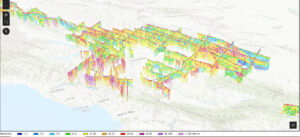
Katherine Dlubac: DWR is conducting AEM surveys across California’s high- and medium-priority groundwater basins where data collection is feasible. We’re focusing on those basins because they are the ones that are required to develop and implement groundwater sustainability plans under SGMA. In these basins, we’re collecting data in a coarse grid, which allows us to cover the entire groundwater basin and provides us with an improved understanding of the large-scale aquifer structure within and across basins. The first surveys were conducted in summer 2021, and surveys are planned to continue into 2023. We conduct the surveys for a few months at a time within specific basins. This past spring, we completed a 3‑month campaign to conduct surveys across the entire Central Valley, which was quite a large undertaking. After the data are collected, they are processed and interpreted and then made available to the public on the California Natural Resources Agency Open Data Portal on a rolling basis about 6–12 months after the surveys are complete. Currently, data reports have been published for the Salinas and Cuyama Valleys, and AEM datasets are available for the Salinas and Cuyama Valleys, Northern California, and the North San Francisco Bay. The data that we collected this past spring in the Central Valley will begin to be posted at the end of 2022. The data and data reports are available at https://data.cnra.ca.gov/dataset/aem.
Irrigation Leader: How does AEM work?
Katherine Dlubac: AEM involves a large loop that is towed beneath a helicopter. As the helicopter flies across the surface of the earth along defined flight lines, it tows the large loop at a height of about 100 feet above the earth’s surface. During the survey, a signal is sent through the loop down into the aquifer. The signals from the aquifer bounce back and are measured on equipment mounted on that loop. We’re measuring the electromagnetic properties of the aquifer materials, specifically their electrical resistivity, which describes the material’s ability to resist an electric current. We know that coarse-grain-dominated materials, such as sand and gravel, are more resistive. Those are the parts of the aquifer that typically store water and are where water can more easily flow. Fine-grain-dominated materials, such as silt and clay, are less resistive. Those materials tend to inhibit or slow water flow within the aquifer. With the data that we’re collecting, we can provide continuous images that show the distribution of materials throughout the aquifer down to a depth of about 1,000 feet.
Irrigation Leader: Does DWR contract with a company to do this?
Katherine Dlubac: Yes; a diverse national and international contracting team is supporting DWR in this work. We contract with Ramboll and SkyTEM, two companies based in Denmark. SkyTEM is the geophysical company that collects the data and Ramboll is a consulting firm with specialized geophysicists who process and interpret the data. Denmark is one of the countries that pioneered this work, and it is quite advanced in using it. The team also includes GEI, which supports DWR in compiling existing data, and Sinton Helicopters, which is a helicopter company with highly experienced pilots. Our team at DWR coordinates with the local groundwater sustainability agencies and state and federal agencies on areas of interest within their basins, develops the plans for the data collection, provides the flight lines to the contractors, conducts presurvey public outreach, publishes the data, and communicates the data to the public.
Irrigation Leader: After identifying the soil types in the aquifers, do you need to cross-check to ensure that the soils in a given aquifer actually contain water?
Katherine Dlubac: We interpret our data with the aid of the information we already have about the aquifers. That includes lithology information from well completion reports, resistivity logs, and e-logs; information on groundwater levels; and information on total dissolved solids concentrations.
Irrigation Leader: Do you create a user-friendly map of the aquifers for the use of local authorities?
Katherine Dlubac: Yes. We’re excited to announce the very recent launch of an innovative new tool that allows the public to view the data: the AEM Data Viewer. This GIS-based tool displays AEM data in a three-dimensional space and allows the user to zoom in and view the data from various angles. The tool is quite nimble and can be accessed on a computer or mobile phone. What’s especially great about this tool is that it does not require the user to download data or to use specialized software, so it can easily be accessed by groundwater managers and groundwater stakeholders. The tool currently displays AEM data for the Salinas and Cuyama Valleys, Northern California, and the North San Francisco Bay. As the data from the statewide AEM survey continue to be published over the coming months and years, we’ll continue to add them to the viewer to keep it up to date. Stakeholders and groundwater sustainability agencies alike will have access to the data reports through the California Natural Resources Agency Open Data Portal and the online AEM Data Viewer.
Irrigation Leader: How will this work support SGMA and the creation of groundwater sustainability plans?
Steven Springhorn: One area where we’re seeing a lot of interest is groundwater recharge projects. The AEM surveys are giving us new information about how the surface is connected to the subsurface, helping water managers identify the best pathways and areas for recharging groundwater. They need to know where the gravels and sands are and how they connect to the surface so they can get water into the ground. They also need to know where the clays are, because if you pump out more than is recharged in certain types of clays, you can have subsidence, or the sinking of the land. This is already occurring in parts of California. AEM survey data will help us better identify areas that are susceptible to subsidence. Local agencies are already using this information to update their hydrogeologic conceptual models and other parts of their sustainability plans under SGMA, which is encouraging.
Irrigation Leader: How might this information be directly relevant to irrigation districts and irrigating farmers?
Steven Springhorn: Local groundwater sustainability agencies are working with landowners and communities in groundwater basins and making tough decisions about how groundwater is going to be used in coming years. The survey data will help these local water managers, working with farmers and other members of the water community, to implement their groundwater sustainability plans.
Irrigation Leader: You mentioned that the statewide survey is almost complete. What are the next steps?
Katherine Dlubac: First, we’ll be finishing up the statewide AEM surveys by collecting data in fall 2022 and spring 2023 in the remaining basins. After that’s complete, we’re going to go back and collect additional AEM data or other types of geophysical data in specific areas to answer defined questions or for specific applications. We may go back to some areas to collect additional AEM data to fill in the coarse grid of data we collected as a part of the statewide AEM surveys. We may also collect towed transient electromagnetic data. This method is essentially the same as AEM except that the equipment is towed behind an all-terrain vehicle. It can provide a higher-resolution picture of the subsurface. We might also collect other types of geophysical borehole data, like nuclear magnetic resonance logging. This is all to say that the statewide AEM surveys were the first step in getting a large-scale understanding of our aquifers, but there will be more work that we will do throughout the state over the next several years to refine and improve that understanding.
Irrigation Leader: Is there anything you would like to add?
Steven Springhorn: If any of your California-based readers are not yet involved in SGMA implementation in their areas, we would highly encourage them to connect with their local groundwater sustainability agencies. It’s important for landowners and other local voices from the community to be involved in these groundwater policy decisions. Local planning and decisionmaking efforts are continuing to happen in basins across the state, and we highly encourage participation at the local level.
Katherine Dlubac is an engineering geologist in the Technical Assistance Section of California’s Department of Water Resources and the project manager of the statewide AEM surveys.
Steven Springhorn is a supervising engineering geologist leading the Technical Assistance Section at DWR.

For more information about the statewide AEM surveys, visit the project website at https://water.ca.gov/programs/sgma/aem or e-mail aem@water.ca.gov.