Irrigation Leader: Please tell us about your background.
Gary Kelliher: I’m a fourth-generation farmer. I initially trained as an engineer. I have lived in New Zealand most of my life, other than 5 years in Ireland. My family operates other businesses as well, both inside and outside the farm. I got involved in water at quite a young age, having been brought up with it. I have been involved in the politics and management of water since we came back from Ireland and began farming on our own account in 2003.
Irrigation Leader: What kind of farming do you do?
Gary Kelliher: We are sheep and deer farmers. We have Romney sheep and red deer. We run some cattle as well, but we like deer, and they are suited to our area. We also have a quarrying business on the farm. We live close to one of the larger towns in our region, Alexandra. We’re surrounded by livestock blocks, horticulture, and a mixture of land use.
Irrigation Leader: Please tell us about your area and the most common crops and livestock there.
Gary Kelliher: We’re located in a mountainous range with productive valley floors. Traditionally, we’ve had finer-wool-type sheep and cattle run on our hill country and in our lower valley floor lands. There is a lot of horticulture and viticulture in our region and in the lower end of the valley; as you go further up the catchment, it gets too high and cold for those activities. Our land use hasn’t seen major changes or huge increases of intensity up until this point—dairying is the more intense form of farming in New Zealand, and there are only about 15 dairy farms in the catchment that I live in. There are about 650 farming properties that access water. Our local town has become popular for retirement alongside its predominant background as an agriculture service center.
Irrigation Leader: Would you tell us about your role in water management?
Gary Kelliher: My perceptions about water management changed as we started the development of our farm. The future of an area like ours, which is incredibly dry, began to concern me. It has a hot summer climate and a dry, cold winter climate. My property gets only 350 millimeters (13.8 inches) of rain per annum. I could see from an early point that involving the entire community in future water decisions was the way to move forward, but that has been a huge challenge.
In 2003, I became a director of Manuherikia Irrigation Scheme (MIS), the local irrigation scheme that our farm was on. The scheme covers 2,500 hectares (6,178 acres), and at the time, the scheme had about 250–300 shareholders. I suppose the board of directors wanted to see some younger blood sitting around the boardroom table. Serving as a director is generally a bit of a thankless task. The scheme had been managed well, but it tends to be the individuals who are passionate or interested in the industry who are prepared to make the time to serve on the board. Eventually, I ended up being chairman of the scheme.
I could see then that I needed to be looking outside the scheme and at the catchment as a whole. There are six irrigation schemes in the catchment. Four of those schemes, including MIS, are in one valley and share in the dam at the head of the valley. Across the catchment, approximately 10,000 hectares (24,710 acres) are irrigated under the schemes in our valley, and another 7,500 hectares (18,533 acres) are irrigated in the other valley that contributes to the catchment.
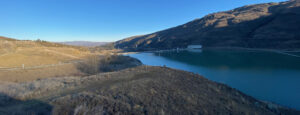
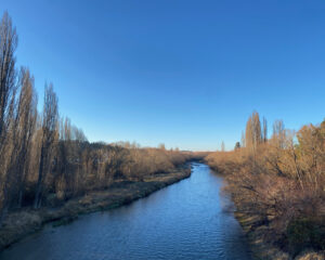
My concern with water in the wider region made me more and more concerned about the future, specifically our consents to take water, most of which are expiring in 2021. That deadline required us to rethink the future and look at alternative sources. The Manuherikia River, which the six schemes in our catchment take from, can have both low and high flows—it can flow up to 600 cubic meters per second (cumecs) in flood, which is about 21,189 cubic feet per second (cfs). The dam at the end of the catchment can augment low flows during dry periods. We have another massive river, the Clutha, at the bottom of the catchment, and it flows an average of 500 cumecs (17,657 cfs), but it’s sort of in the wrong place. We have a lot of water, but we need to identify the best sources and how best to use them.
I worked closely with Irrigation New Zealand, and MIS helped to develop a small new scheme that now has about 1,300 hectares (3,212 acres) of new irrigation at the lower end of the valley. We could have done a lot more. We do hold a balance of water available for that.
In around 2011–2012, the six schemes in the catchment established the Manuherikia Catchment Water Strategy Group (MCWSG), an all-inclusive strategy group for the catchment with an independent chair. I was deputy chair. It included all the segments of the community that wanted to take part. Working in that strategy group, I began to wonder whether I should stand for election as an ORC councilor. I was elected in 2013 and served a 3‑year stint. A well-known New Zealand politician stood for the same position in 2016 and beat me by five votes. I continued with my catchment work until I stood again and was reelected in 2019. This time around, I’m not involved as much with the catchment. I don’t hold an official position with the MCWSG today, but I interact with it closely as we work through the issues.
The MCWSG was a community group without an official status, but it did approximately NZ$2 million (US$1.4 million) worth of investigatory work over several years under our local council’s banner. However, we reached a point at which the six schemes needed our own entity for the catchment, and we established Manuherikia River Limited to eventually own and manage the infrastructure for all six schemes.
Irrigation Leader: So a scheme like MIS owns some of its own infrastructure and also uses other infrastructure that is owned in common with the other five schemes in the catchment?
Gary Kelliher: MIS owns its own intake and a canal system to deliver water to the properties. The scheme is moving toward more piped delivery on the peripheries, but it plans to continue using its canal system from the river. The four schemes in the valley share storage in the dam at the head of the catchment. The dam is owned by the scheme in the upper valley. The end preferred model would be for ownership to sit with all the schemes, because the dam plays a part in managing the river during dry seasons. Over a 10‑year period, we will have at least two seasons during which we have to heavily ration what we take out of the river and heavily rely on that storage.
Irrigation Leader: What were the main points of contention between the different schemes that led you to move toward whole-catchment management? Were they mainly related to water allocation or to the costs of infrastructure?
Gary Kelliher: Both. The schemes have historically been owned and operated separately, but since they share in the dam, there has always been a robust debate around where the water is most needed—in the upper valley or the lower valley—and how best to conserve the water in the dam. The lower valley has always pushed to conserve as much water as possible within the dam, and the upper valley tends to want to work the dam harder and lift the reliability that it created. In the lower valley, the reliability was needed most by our horticultural water users. We needed to move past that and establish a common understanding, and that was done relatively easily. We hoped that by involving the environmental groups and the wider community in the MCWSG and giving them a better understanding of the system’s hydrology and how water users across the catchment manage the river, we would end up with a path forward.
The MCWSG is required to set a minimum flow for environmental protection at the bottom of the catchment. There was already a minimum flow midway down the catchment. We also needed the minimum flow to establish certainty around what we could do with the dam, which is an earth-filled, concrete-faced dam constructed in the 1930s. It has some spillway capacity issues related to requirements for greater flood flow capabilities. It has an enclosed glory hole spillway, so we were always going to have to construct a new overlay over the crest spillway at some point. The major questions for us were whether to build a new dam or whether to increase the height of the existing dam, and if so, by how much. We hoped that was well understood by all and that we could arrive at a close understanding of each other. Unfortunately, the reality was totally the opposite.
Irrigation Leader: What are the major remaining disagreements within the catchment?
Gary Kelliher: They mainly relate to the river level. We gathered a lot of information to try to understand what we could and should do, but that ended in 2017 or 2018, because until we were able to set a minimum flow, we could not decide how to rebuild the dam or know what reliability it could provide to the water users. We have worked to meet a voluntary flow target of 900 liters per second (31.8 cfs) at the bottom of the catchment.
After 2018, the ORC established a new group called the Manuherikia Reference Group (MRG) with an independent chair. This was another all-encompassing group that included the water users and environmental groups. The intention was to give the MRG the ability to set the minimum flow. The ORC also established a technical advisory group so that the MRG could request technical and scientific information and make informed decisions. When, in the last few months, we saw the outcome of the MRG’s 3 years of work, it caused an uproar in the community, because it did not provide a narrow and detailed set of targets. The range it provided is outside what can be provided with the current dam. It’s an aspiration that is so high it’s not funny.
The reason that has occurred is that the ORC has long believed that our catchment needed a sort of game-changing hit on the head to rectify the river. It turns out that the science is saying, “The river is in good health whether it’s at high flow or low flow, and the varying attributes of the river can all be provided for.” That doesn’t match with the ORC’s belief that an increase in flows will remove the risk of intensity and will better the river. Now, the water users have had to go public with the message that achieving higher flows will absolutely cripple the economy. That has now become the debate, and it’s a real shame that it has ended up that way.
Irrigation Leader: What are the next steps you are going to take?
Gary Kelliher: The water users in the catchment have no faith that the council or environmental interests are using defensible science in their decisionmaking. The water users have done the science that you would expect the ORC itself to have done, and because of that, the water users feel that they are in a position to justify the low flows and to be able to show the community that it is in both the river’s and the community’s best interest to use their lower indication of a minimum flow of 1,100 liters per second (38.8 cfs).
New national planning requirements mean the ORC must prepare a new comprehensive land and water plan by 2023. The ORC was planning to just get through a consultation phase with the community around the Manuherikia catchment and then wait until the new land and water plan was announced in 2023 for formal consultation and regulations.
The next steps are for the water users to work hard with the community to show the community that the water users’ model is the right way forward and that it works in everybody’s best interests and in the river’s best interests.
New Zealand’s current government has put out a national policy statement that establishes a hierarchy according to which the rivers must be managed. The health of waterways must now always come first; the health of people comes second; and other uses of water, such as economic uses, come third. That is an aspirational way to protect a river, but I haven’t panicked too much about it, since if you don’t have the economic means to do what you’re hoping to do on level 1, it sort of ruins your ability to do anything on levels 2 or 3. I think the three need to work in parallel to come up with a sensible outcome.
Irrigation Leader: What are the other top issues of MIS and the other schemes?
Gary Kelliher: The water users have always proven with how they’ve managed the river that they are conservationists. My children grew up swimming in the river, I did too, and my father did before that. We’re protective of our rivers, so we suffer continually because of the perception that water users are the pillagers of the river. That makes us feel defensive, because we all live in this community.
We own and manage our infrastructure, and we will continue to manage it. By grouping together, we’ll be able to have farmers making decisions on infrastructure that normally would be managed by a municipal system with the town. The decisions about what standard of dam we will build and to what height we’ll build it are well advanced, but having them under one umbrella and having the expertise of our engaged professional team will be advantageous for the catchment. There will be environmental monitoring to a greater extent across the catchment, and the schemes will manage it. In our catchment, it is possible for there to be an absolute win-win for everybody. Everyone can have what they would like to have within our catchment, whether it’s safe swimming, habitat for fisheries, or water use.
Irrigation Leader: Was there anything else you wanted to discuss that we haven’t touched on yet?
Gary Kelliher: There is an urban-versus-rural divide developing in New Zealand. Our central government, our regional governments, and to some extent our local government seem to be almost opposed to agriculture and horticulture. New Zealand agriculture provides produce to the world and provides a great tourism experience, and we are proud of our clean, green image. Yet we have an environmental lobby that is now quite influential in our central and regional governments and is costing the community, especially the water users and the irrigators, massively. They are experiencing a lot of stresses and uncertainties. We need long-term water consents to provide certainty and enable investment, and we’re really battling to get those. Local councils can’t upgrade their infrastructure without long-term, bankable consents, but regional councils, which are the consenting authorities, don’t want to give the irrigation sector the long-term consent it needs to upgrade the structure. We need to get past that.
Gary Kelliher is a New Zealand farmer and an elected member of the Otago Regional Council. He can be contacted at gary.kelliher@orc.govt.nz.